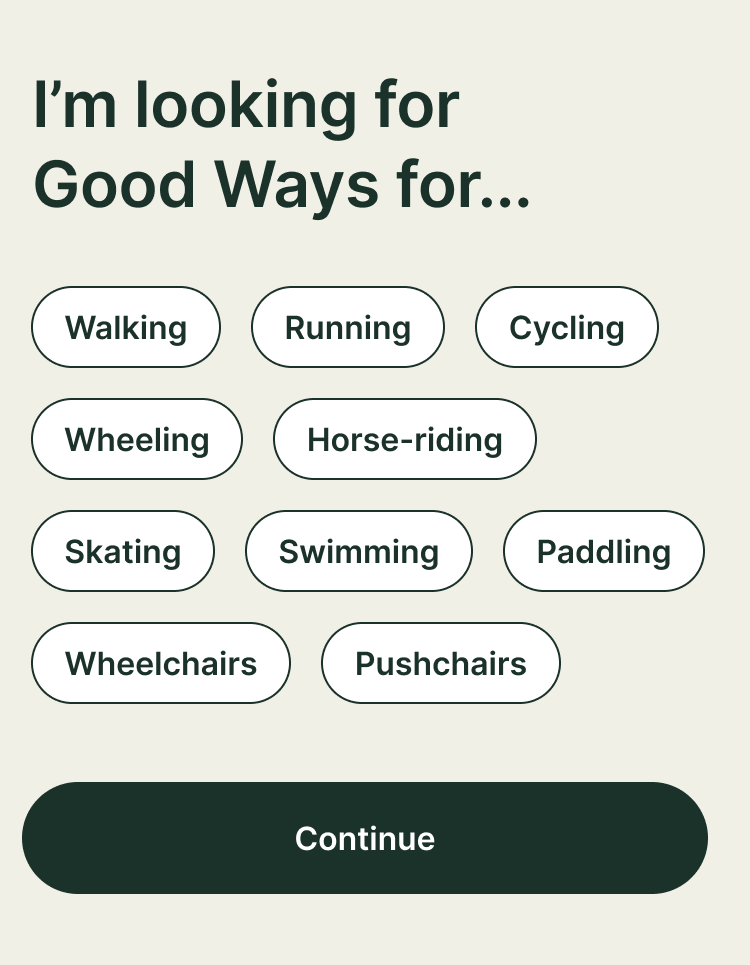
A screen from the prototype app saying "I'm looking for Good Ways for..." and then a choice of buttons saying walking, running, cycling, wheeling, horse-riding, skating, swimming, paddling, wheelchairs and pushchairs.

Update 3: What kinds of movement should Good Ways support?

As we develop the Good Ways app we’re keen to hear your thoughts, ideas and opinions. There will be lots of opportunities to feedback on questions, prototypes, the app and project as a whole.

Sometimes we will share rough and raw things that we know are not finished yet. We’ll be doing that intentionally so we can listen, learn and make improvements.

This post is the first of many that we’d love you to respond to.

We want to share Good Ways for lots of different types of people-powered movement, travel and adventures.

We’ve said on our home page that we want to make it easier for everyone to enjoy Good Ways for walking, running, cycling, wheeling, horse-riding, skating, swimming, paddling, wheelchairs and pushchairs.

What ways of getting about would you like us to include?

  • Are there other or more specific ways of getting about you’d like us to include?
  • Would you like part of the app to be just for one type of movement?
  • Should getting about by wheelchair be considered as walking or have its own top-level category?

We can’t do everything.. and certainly not all at once.. but what should our priorities be?

We’d love to know what you’d like Good Ways for.

Let us know by commenting below!

You’ll need to sign-up to comment.


Comments

9 responses to “Update 3: What kinds of movement should Good Ways support?”

  1. Lucy Bomford avatar
    Lucy Bomford

    I’m a keen (leisure) cyclist, and one of the things I find hard and would like to explore is mapping out traffic-free and low-traffic routes. There are the obvious lovely cycle paths, but it would be great to make it easier to link in to these from different locations via safe, low-traffic routes.

  2. Kelly Smith avatar
    Kelly Smith

    Hi,
    I quite liked this not much more to comment.

  3. claremockridge avatar
    claremockridge

    Re horses and riders. I suggest you reach out to the British Horse Society. They are the well-established national voluntary organisation supporting horse owners, riders and training and they are not at all wild, but they have a big membership, including non horsey-central riders like me who ride out on roads and take advantage of their member public liability insurance policy. They are also interested in inclusivity and looking to increase their relevance and range plus, crucially, one of their core purposes is access and bridleways. They have campaigned, for example, on the issue of making sure that bridleways not currently mapped as such are included on the OS maps and they work on access issues. Their latest mag has an article on riding routes

  4. Rowena Macaulay avatar
    Rowena Macaulay

    This might be further down the line, and may ultimately be something different from what’s envisaged now, or how the app evolves in practice. I would certainly love a map that enables me to find good routes for handbike users etc in my local area or in order to travel to base a holiday around, say, which I know is what is envisaged here and what we’re working towards (that and many other interest-related kinds of routes of course).

    But my personal main interests are in route-recording, improvement, barrier removal, connectivity etc. So in a sense my interest is in identifying ‘bad ways’, in order to identify for example the places where funds can be invested to greatest effect, where improved short stretches or individual barrier interventions would do most to open up other stretches and so on. I would love to have a map that individuals, organisations, and statutory agencies working in related fields can collaborate around, share knowledge, negotiate priorities, communicate with other regions of the country and inform best practice.

    I would like a facility that genuinely offers the tools to create better ways and, importantly, to speed this insanely slow process up (referring to information-sharing and barrier identification and removal)!

    It’s just occurring to me now, but a big problem in taking such initiatives forward is that, without the tools to work on them remotely, the people who benefit most from these kinds of route improvements (eg mobility-restricted walkers and chair-users) are entirely reliant on non-disabled people to advance them, because the barriers themselves prevent them getting out there are to map, geo-locate, record etc. And yet this latter group have less interest or motivation to do so, for no bad reason, but simply because the same issues don’t impact them, so they dont see/experience the landscape in the same way unless they have specific reason to be alert to it.

    So I hope for an app that isn’t ultimately just about finding leisure routes now because I have a free w/e and want to get out there (I DO want that), but is also work-focused.

    1. Dan Raven-Ellison, Good Ways CEO avatar
      Dan Raven-Ellison, Good Ways CEO

      Thanks Rowena, really powerful and useful insights. I hear you – we need to make paths better… and not just passively accept and map what’s already there.

  5. Sophie Sadler avatar
    Sophie Sadler

    I would love to be able to see where the best viewpoints are along routes! And with more nuance than existing apps – sometimes they show a specific lookout point, but you won’t know if a whole path has a good view along it, for example, vs paths which may be high up but hidden in the trees.

    For running it would be really helpful to distinguish road routes vs trail routes or those that are a mix of both. For road running, it would be great to have recommended routes that avoid lots of road crossings (which interrupt the flow of running)! And also being able to see where steep hills are.

    For horse riding, some useful things would be knowing routes that are legally accessible for horses (i.e. 100% bridleways / roads), but also being able to check condition (e.g. sometimes a fallen tree means a walker can get past but not a horse, or probably not a wheelchair user as well!) including ground condition (it’s helpful to know when the terrain is really hard or really boggy to keep your horse’s legs safe and find good paths to go faster). In some areas there are mounting blocks, it would be good to know the location of these as well.

    In fact for all of walking, running and horse riding it would be nice to know the % of the route which is along roads or paved surfaces.

    For paddle boarding (and other water sports) there’s lots of things that could be helpful as well – easy access points are one thing (but there are other apps for this specifically), but also suggested routes, showing portage sections along river routes, fishing hotspots, maybe information like E Coli levels (I think these are available), areas with nesting birds (many water users might be ignorant about avoiding vulnerable wildlife).

    I’m sure there will be many more ideas over the coming months, but these are some things I’d love to see!

    1. Dan Raven-Ellison, Good Ways CEO avatar
      Dan Raven-Ellison, Good Ways CEO

      Thanks Sophie. Really helpful. Knowing about good places is as important as Good Ways!?

  6. Jo Treweek avatar
    Jo Treweek

    Hi!
    It seems there are two main categories of horse rider.. people doing local “petal rides” (circular routes from a point) and people interested in long riding… long routes that join up. The biggest gap in what’s available is the long rider category, especially ability to find good local off-road routes that can form part of a longer multi-stage journey. Key to making a longer journey possible is horse friendly stop-overs as previously discussed. My personal vote is for wilder ways by horse!

    1. Dan Raven-Ellison, Good Ways CEO avatar
      Dan Raven-Ellison, Good Ways CEO

      Great feedback, thanks Jo. Would love for Good Ways find all those great off-road routes.

Leave a Reply